play video

Get the whole traffic picture

Insight

A new way to understand what’s happening
on Australian roads.

play video

Advancing the mobility revolution

Insight data used and trusted by

Product Features

feature video

Product Features

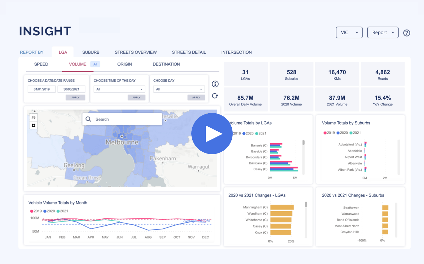
The changes in traffic volume over time

Traffic volume data provides in-depth information about the impact of events, projects or infrastructure changes to the amount of traffic on the road.
Compare the traffic volume on roads, in suburbs, by local government areas, or turning at intersections over 15 minutes, days, weeks, months or years.

roads video

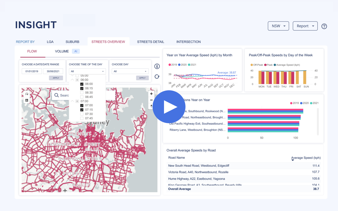
Roads that are congested

Traffic speed data is instrumental for making data-based decisions to improve traffic flow and mitigate congestion. Compare the traffic speed on roads, in suburbs, or local government areas over 15 minutes, days, weeks, months, or years.

traffic video

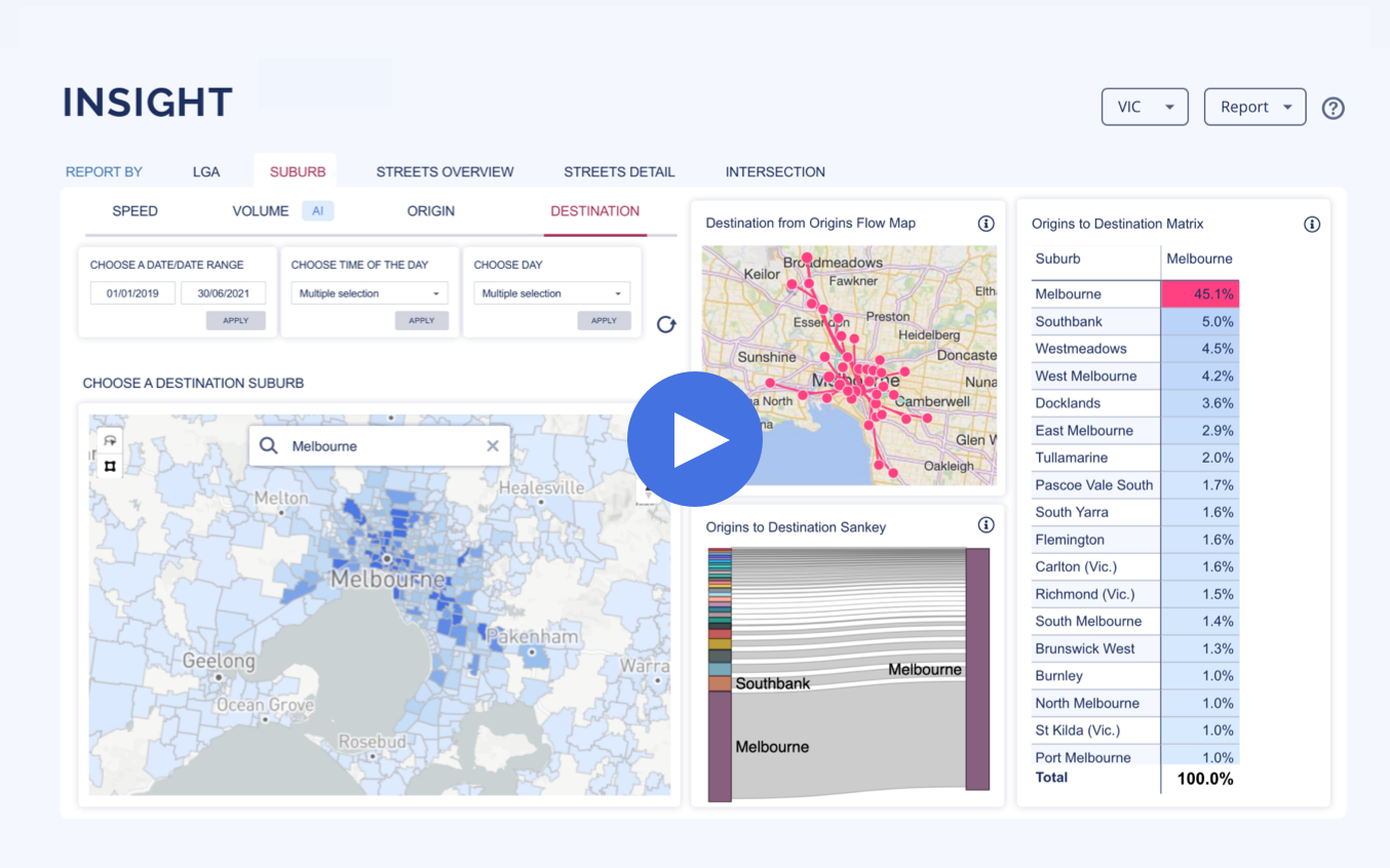
Where traffic is coming from / going to

Traffic origin-destination data shows the changes in people’s mobility behaviour over time.
Compare where people travel to and from by suburb or local government area over 15 minutes, days, weeks, months or years.

COMING SOON

Turning volume at intersections

Traditional traffic survey methods take time. A lot of time. And only provide a snapshot in time. Access 15-minute increments of peak and off-peak traffic analytics, by street or entire suburbs, in seconds.

Swinburne University of Technology’s Predictive Traffic Intelligence model is a deep learning neural network that processes in forward and reverse time, in order to predict. The key in achieving accuracy is in obtaining a large and representative dataset, and Insight was ideal for this.

Hussein Dia
Professor of Future Urban Mobility, Swinburne University

Product highlights

Get the whole traffic picture. In seconds

Traditional traffic survey methods take time. A lot of time. And only provide a snapshot in time. Access 15-minute increments of peak and off-peak traffic analytics, by street or entire suburbs, in seconds.

Plan, assess and evaluate projects without tube counts

Tube counts break and open source data is unreliable. The power is in comprehensive, validated data. Traffic engineers, transport professionals and urban planners increase productivity with rich, up to date and reliable traffic data.

Actionable insights from a comprehensive array of sources

How can you ensure traffic data quality? We collect data from an array of sources including real-time probes in commercial and private vehicles, millions of road sensors, intersection nodes, cameras, and traffic signals, for the most accurate results every time.

96% accuracy against traffic loops on the roads

Verifying and cleansing traffic data has already been done. To ensure the highest quality data in the market, all traffic data is validated by verifying against traffic sensors, 100+ million trips, traffic surveys and 24/7 control groups.

Tools to get the job done

One source = all of your traffic insights. Get the job done with an extensive range of tools to analyse traffic flow and congestion, volume, origin and destination, turning movements, and vehicle class.

Get insights from the traffic experts

For 12-consecutive years Intelematics has remained Australia’s leading traffic information provider. You can’t beat that.

Choose a better way to work

Traffic analysis tools for future planning

Eagles eye view of several motorways converging

Data & coverage

High-quality road traffic data is gathered, verified, and analysed to provide actionable insights on Australia’s extensive road network.

Industries

Traffic engineers, transport and city planners, and government bodies use Insight’s rich traffic data and analytics to get the whole picture.

Case studies

Traffic projects are planned, managed and evaluated using Insight. Learn how Insight is used to assess the Hoddle Street Streamlining Project.

Want to know more?

Speak to one of our Insight traffic data experts

Frequently asked questions

Insight from Intelematics is a game-changer for traffic engineers, urban planners, sustainability experts, project managers and transport professionals in Australia. It processes 12 billion rows of traffic data in under 30 seconds. The gathering, verifying, cleansing and analysing of data has already been done and provides actionable insights about Australia’s road network.

Insight hosts road and traffic data covering more than 40,000kms of NSW and Victorian roads. Coverage of NSW includes 39 Local Government Areas (LGAs), 1,058 suburbs, and almost 5,000 roads. Coverage of Victoria includes 32 LGAs, 566 suburbs, and almost 5,000kms of roads.

Look back from January 2019 to now, and understand traffic trends over years, months, weeks, days, or even by 15-minute segments.

As Insight publishes highly accurate mobility data all in one online solution, it is used by a variety of industries and professionals. Industries that currently use Insight include government organisations, local councils, the media and their journalists, academic bodies and universities, traffic engineering firms, construction companies, real-estate firms, retail stores, and service providers. 

Using Insight, activities are performed such as scenario planning, costing out infrastructure builds, reporting on traffic conditions, researching for academic papers, determining construction locations, improving road and active mobility safety, responding to tenders, responding to constituent requests, and evaluating the impact of changes such as new speed limits, introduced safety measures, and special events.

The data accuracy and quality of Insight are what sets it apart. Data is collected from various sources and verified to ensure the highest quality road and traffic analytics in the market. 

The sources include real-time probes (GPS hardware) from vehicles on the road, in both commercial and private fleets, and millions of node sensors on the roads and at intersections that measure real-time traffic volume and light cycles. In addition to multimodal movement data from a range of anonymised IoT devices.

Real-time data from emergency services and road authorities about the conditions on the roads provide contextual information to calibrate the data sources further. 

The data’s quality is ensured through cross-validation by 24/7 control groups in the field and machine taught algorithms. Modelling in Insight provides meaningful and actionable insights. As we have unrivalled experience in capturing and providing traffic data through 20+ years of investment in research and development, our data is the most up to date and has been obtained adhering to the most stringent guidelines. Download our white paper and learn more about Insight’s traffic data collection, verification and methodology.

In NSW, Insight road and traffic data covers:

Sydney, Inner West, Canterbury-Bankstown, Ryde, Bayside, Randwick, Parramatta, Willoughby, North Sydney, Northern Beaches, Blacktown, Fairfield, Liverpool, Woollahra, Sutherland Shire, Cumberland, Ku-ring-gai, Waverley, Georges River, Mosman, Canada Bay, Strathfield, The Hills Shire, Lane Cove, Hornsby, Hunters Hill, Campbelltown, Wollongong, Burwood, Camden, Central Coast, Shoalhaven, Penrith, Newcastle, Shellharbour, Lake Macquarie, Hawkesbury, and Queanbeyan-Palerang Regional.

In Victoria, Insight road and traffic data covers:

Melbourne, Casey, Wyndham, Hume, Greater Geelong, Brimbank, Greater Dandenong, Whittlesea, Knox, Mornington Peninsula, Monash, Whitehorse, Port Phillip, Yarra Ranges, Frankston, Kingston, Maroondah, Yarra, Manningham, Darebin, Banyule, Boroondara, Hobsons Bay, Moonee Valley, Maribyrnong, Moreland, Glen Eira, Stonnington, Nillumbik, Bayside and Golden Plains.